Look for a
lock () or https:// as an added precaution. Share sensitive
information only on official, secure websites.
SLA announces new collaborations to deepen regional skills development in land administration and management, and support solutions to tackle Singapore’s urban heat effect
- Partners the National Land Commission Secretariat of Bhutan for skills development to establish a robust land administration and management regime
- Inks inaugural collaboration with SMU to support national efforts to reduce Singapore’s urban heat in the built environment and urban greenspace and enhance climate change resilience
Singapore, 3 June 2024 – The Singapore Land Authority (SLA) today unveiled two new strategic partnerships to expand its geospatial and land management expertise to deepen regional skills development through the establishment of a comprehensive and robust land administration and management regime, and support solutions to tackle Singapore’s urban heat effect. The collaborations were announced at the Singapore Geospatial Forum, organised by SLA, at the 9th World Cities Summit 2024.
Regional skills development to establish a robust land administration and management regime
2 The Kingdom of Bhutan and Singapore enjoy warm bilateral ties, sharing mutual understanding and common interests as small States with limited land[1].
3 Today, SLA inked a Memorandum of Understanding (MoU) with the National Land Commission Secretariat (NLCS) of Bhutan to collaborate on skills development in support of Bhutan’s national development through the establishment of a comprehensive and robust land administration and management framework, and to explore opportunities to deepen Bhutan’s geospatial capabilities. Please refer to Annex A for details of the partnership.
4 To mark the agreement, a Memorandum of Understanding (MOU) was signed by Mr Tshering Gyaltshen Penjor, Secretary, NLCS, and Ms Thong Wai Lin, Deputy Chief Executive, SLA.
Reducing Singapore’s urban heat effect and enhancing climate change resilience
5 Singapore has been warming up twice as fast compared to the rest of the world, at 0.25 degrees Celsius per decade, according to Singapore's Meteorological Service[2]. To enhance Singapore’s resilience to climate change, there is a critical need to address the issue of urban heating and its impact to the ecosystems and public health.
6 Today, SLA embarked on a partnership with the Singapore Management University (SMU)’s College of Integrative Studies (CIS) and Urban Institute (UI) to jointly collaborate on leveraging geodata to support research projects on climate change and urban challenges, including Cooling Singapore 2.0, a multi-disciplinary research project which SMU co-leads and is dedicated to developing solutions to address the urban heat challenge in Singapore, in support of the SG Green Plan (SGP) 2030.
7 The collaboration concurrently enriches the geospatial talent pipeline through participation in co-led activities or collaborative research projects and undergraduate/postgraduate research opportunities, as well as events to promote greater geospatial outreach and awareness. Please refer to Annex B for more details of the partnership.
8 A Memorandum of Understanding (MOU) was signed by Professor Elvin Lim, Dean, CIS, Ms Thong Wai Lin, Deputy Chief Executive, SLA, Associate Professor Orlando Woods, Director, UI, and Mr Sin Lye Chong, Assistant Chief Executive, SLA.
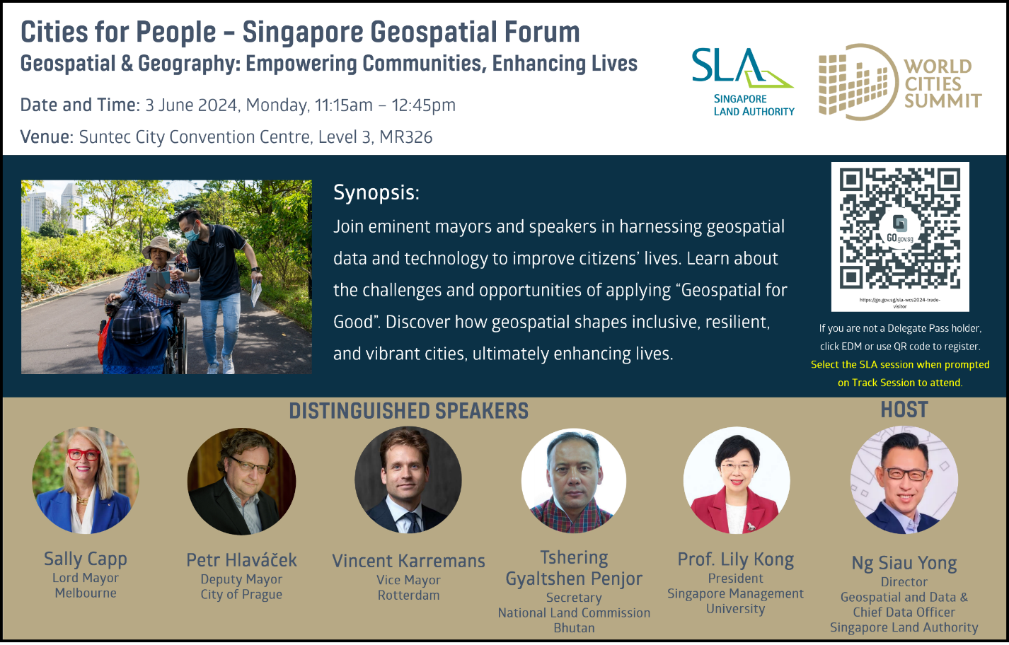
9 In line with the WCS’ theme of building liveable and sustainable cities, SLA hosted a geospatial forum today, entitled “Cities for People – Geospatial & Geography: Empowering Communities, Enhancing Lives”, where five distinguished speakers including Mayors from major cities such as Melbourne, Prague and Rotterdam talked about the challenges and opportunities of mainstreaming geospatial, and shared insights on how geospatial technologies are leveraged to build inclusive, resilient and vibrant cities to improve citizens’ quality of life. Please refer to Annex C for more details of the forum.
10 The latest collaborations reinforce the key strategic pillars outlined in the recently announced SG Geospatial Master Plan 2024 – 2033, to extend global partnerships, deepen geospatial capabilities and mainstream geo-technologies for social, community and sustainability outcomes.
[2] http://www.weather.gov.sg/climate-past-climate-trends/
=== End ===
Issued by:
Singapore Land Authority
3 June 2024
ANNEX A
Memorandum of Understanding between SLA and the National Land Commission Secretariat (NLCS) of Bhutan
Objectives
SLA will provide consultancy services to NLCS to support Bhutan’s national development and to achieve its vision of a “Spatially Enabled Nation with Par Excellence Land Governance”.
In the next two years, SLA will work with NLCS to establish a comprehensive and robust land administration and management regime (through legislative and regulatory framework reforms). Specifically, SLA will help NLCS strengthen its capabilities in the areas of land acquisition and provide guidance to develop a legislation and administration framework. SLA will also support NLCS in the use of established valuation methods and approaches to determine the market values of properties that are affected by land acquisition. In addition, SLA will explore opportunities to deepen Bhutan’s geospatial capabilities.
Photograph of MoU signing
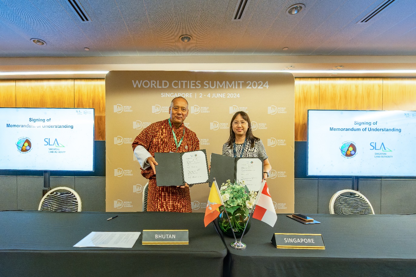
[From left to right] Mr Tshering Gyaltshen Penjor, Secretary, National Land Commission Secretariat, Bhutan, and Ms Thong Wai Lin, Deputy Chief Executive, SLA, signed a Memorandum of Understanding to support national development in land administration and management in the Kingdom of Bhutan.
Quotes
“The MoU signed between SLA and the NLCS is testament to the longstanding warm relations between our countries. SLA is honoured to be cooperating with NLCS for skills development and capability building in land administration and management, and geospatial capabilities. We look forward to working closely with Bhutan to jointly empower communities, enhance lives and drive economic and social progress in the region.”
- Ms Thong Wai Lin, Deputy Chief Executive, SLA
"This partnership exemplifies the strong and enduring ties between Bhutan and Singapore. By collaborating with the Singapore Land Authority, we anticipate significant advancements in our land governance framework. This will not only enhance our land management practices but also support Bhutan’s sustainable development goals. The expertise and support provided by the Singaporean government and SLA are invaluable to us, and we are sincerely grateful for their commitment. This MoU is a testament to our shared vision and mutual respect, and we look forward to a fruitful partnership that will benefit our nations for many years to come. We are confident that with continued cooperation, we can achieve great strides in land administration and geospatial capabilities, paving the way for future growth and prosperity."
- Mr Tshering Gyaltshen Penjor, Secretary, NLCS
ANNEX B
Memorandum of Understanding between SLA and SMU
Objectives
SLA and SMU CIS/UI will jointly collaborate on areas of mutual interests, such as climate change, urban challenges and in particular urban heat effects, as well as geospatial education, trainings and outreach.
SLA’s geospatial information, including 3D data products (such as lidar scans, orthophotos, DSM and DTM) and licensed datasets (such as street maps), will enable accurate and comprehensive data for education and research purposes in support of the Cooling Singapore 2.0 research project.
One of the goals of the Cooling Singapore 2.0 research project is to develop a Digital Urban Climate Twin (DUCT) of Singapore to explore the heat effects of buildings, transport and industry, and to enable its users to conduct simulation experiments and explore what-if scenarios. Insights, such as examining locations in Singapore where exposure to urban heat is severe, can be used to support policymakers and urban planners in their decision-making to adapt to climate change by reducing heat vulnerability of Singapore’s population.
The creation of the DUCT with enhanced geospatial mapping data will address the impact of future urban development on the urban climate, and aid policymakers in Singapore to assess effective climate adaptation solutions that can enhance the city’s climate resilience.
SLA and SMU CIS/UI will also enrich the geospatial talent pipeline through participation in co-led activities or collaborative research projects and undergraduate/postgraduate research opportunities, as well as events to promote greater geospatial outreach and awareness.
Photograph of MoU signing
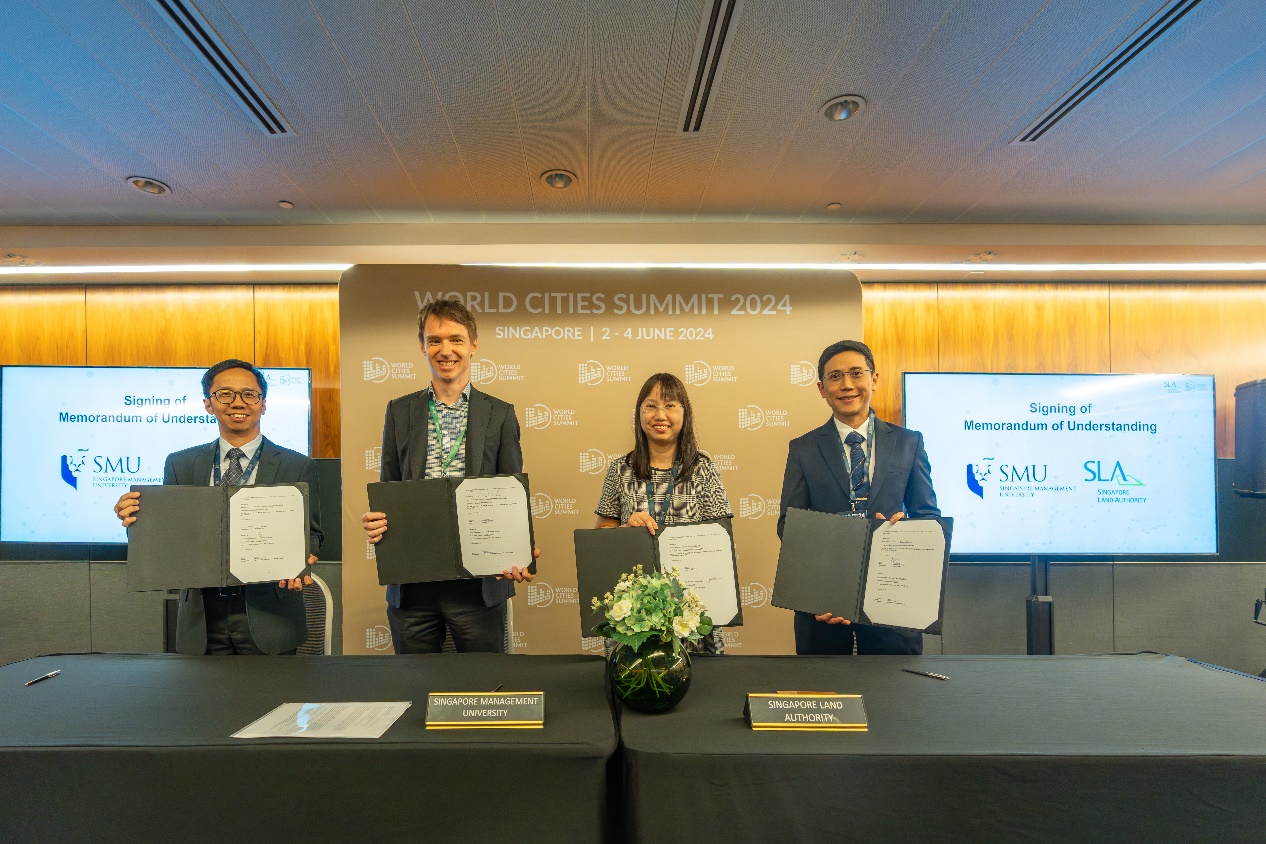
[From left to right] Mr Sin Lye Chong, Assistant Chief Executive, SLA, Associate Professor Orlando Woods, Director, UI, Ms Thong Wai Lin, Deputy Chief Executive, SLA, and Professor Elvin Lim, Dean, CIS, signed a Memorandum of Understanding to collaborate on climate research projects and research opportunities.
Quotes
“As the national geospatial and mapping agency, SLA is honoured to embark on this inaugural partnership with SMU to help Singapore become a more climate resilient and sustainable city. Geospatial technology has enabled a variety of climate mitigation solutions and it is timely to leverage its expertise to combat climate challenges such as urban heat effects, which can be detrimental to Singapore and the region. The collaboration with SMU also presents opportunities to nurture and develop a talent pipeline to deepen Singapore’s geospatial capabilities.”
- Ms Thong Wai Lin, Deputy Chief Executive, SLA
“SMU very much values our partnership with Singapore Land Authority. With this initiative, we are a step closer to improving urban living through geospatial technology. By leveraging on the strengths of our Urban Institute, we aim to undertake rigorous research to enhance our understanding of cities and its urgent challenges, such as urban heating and its related social impacts. By creating more opportunities for collaboration amongst faculty, students and members of industry in this space, we intend to grow a pool of talent that is committed to laying the groundwork for building liveable, resilient and inclusive cities in Asia.”
- Professor Lily Kong, President, SMU
ANNEX C
Singapore Geospatial Forum
Cities for People – Geospatial & Geography: Empowering Communities, Enhancing Lives
Hosted by Mr Ng Siau Yong, Director, Geospatial & Data and Chief Data Officer of SLA, this panel discussion explores the adoption of geospatial technologies to improve citizens’ quality of life, in the social, cultural and healthcare aspects. Discover how mainstreaming geospatial strategies can shape more inclusive, resilient and vibrant cities.
Distinguished Panelists :
- Host: Mr Ng Siau Yong, Director, Geospatial & Data and Chief Data Officer, SLA
- Speaker: Ms Sally Capp, Lord Mayor, Melbourne
- Speaker: Mr Petr Hlaváček, Deputy Mayor, City of Prague
- Speaker: Mr Vincent Karremans, Vice Mayor, Rotterdam
- Speaker: Mr Tshering Gyaltshen Penjor, Secretary, National Land Commission Secretariat, Bhutan
- Speaker: Professor Lily Kong, President, SMU