SLA inks new Memorandum of Understanding with OGC to expand community and industry outreach and enhance geospatial capabilities at 6th Singapore Geospatial Festival
Singapore, 15 October 2024 – The 6th Singapore Geospatial Festival 2024 (GeoFest) returns this year from 15 – 17 October 2024. Organised by the Singapore Land Authority (SLA), this year’s theme of “Geospatial for Good: Enriching Minds, Empowering Lives”, highlights the transformative impact of geospatial technology on social good and youth education.
2 This annual event brings the geospatial community together for talks, panel discussions, workshops and co-located activities promoting the innovative use of geospatial information and technology.
3 The opening session will be held at the Lifelong Learning Institute on 15 October 2024, Tuesday at 9am. Please refer to Annex A for the opening address by Mr Yeoh Oon Jin, Chairman, SLA.
Extending Global Outreach
(i) Memorandum of Understanding with Open Geospatial Consortium
4 SLA will collaborate with Open Geospatial Consortium (OGC) to drive community and industry outreach, harnessing synergies and exploring technical partnerships, workshops and trainings to enhance geospatial capabilities in Singapore.
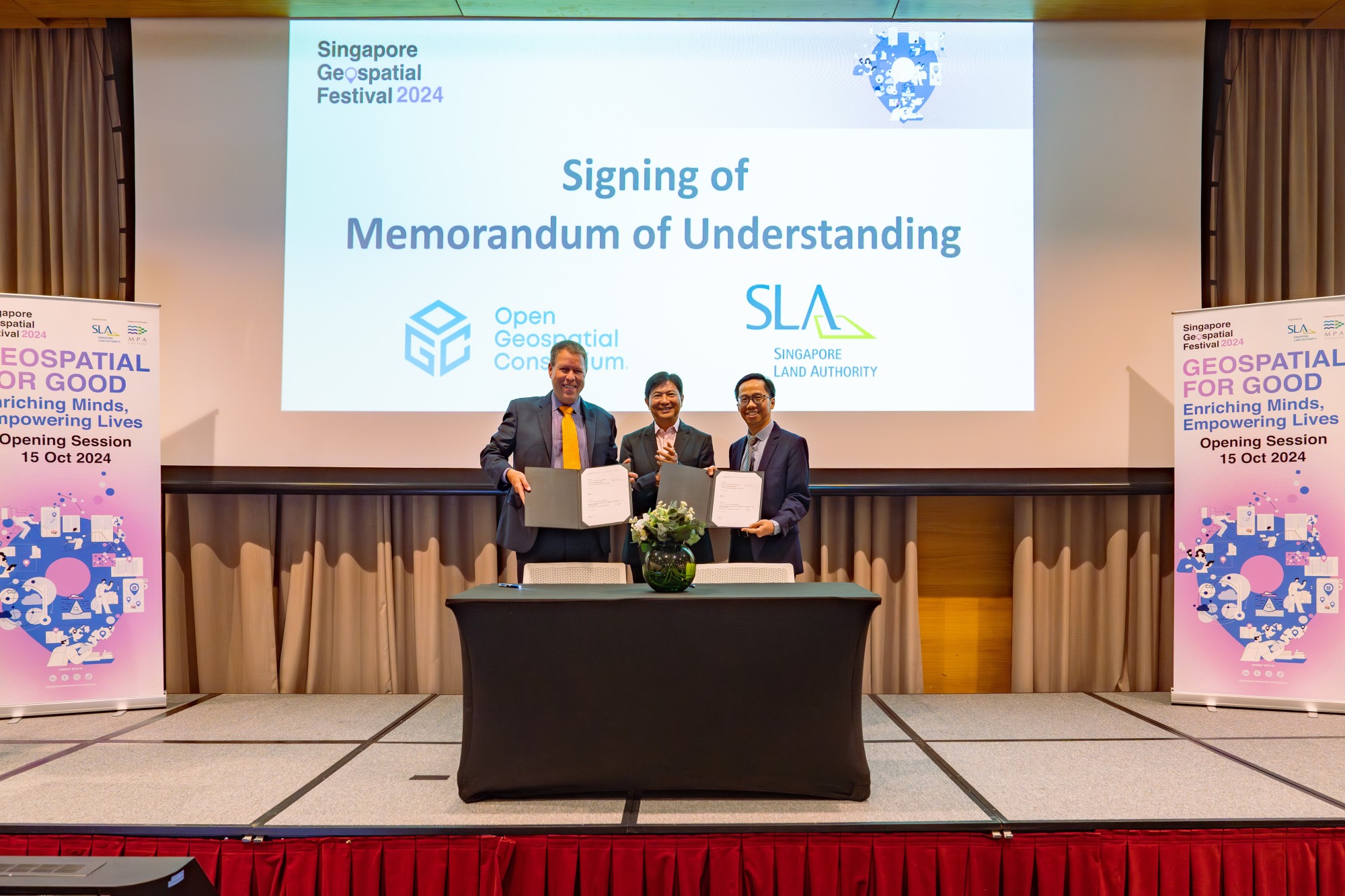
5 A Memorandum of Understanding (MOU) was signed by Mr Sin Lye Chong, Assistant Chief Executive (Geospatial & Engagement) and Chief Sustainability Officer, SLA and Mr Scott Simmons, Chief Standards Officer, OGC, and witnessed by Mr Yeoh Oon Jin, Chairman, SLA, at the opening ceremony of GeoFest 2024.
Please refer to Annex B for the photograph of the signing ceremony.
Promoting Geo-enabled Living
(i) ULI-Singapore SLA Forum
6 Geospatial technologies are transforming how nations design, plan, and sustain urban environments. Now, more than ever, these tools are crucial in creating communities that are inclusive, resilient, and sustainable.
7 In an effort to further mainstream geospatial expertise and promote community-centric living, SLA and Urban Land Institute (ULI) will hold an inaugural ULI-Singapore SLA Forum on 17 October 2024, 4pm – 6pm.
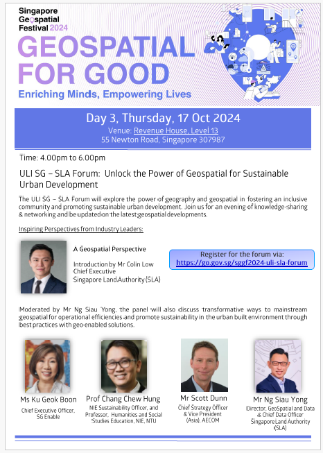
8 The ULI-Singapore SLA forum will explore the power of geography and geospatial in fostering an inclusive community and promoting sustainable urban development. The panel discussion, moderated by Mr Ng Siau Yong, Director, Geospatial & Data and Chief Data Officer, SLA, will delve into the transformative ways geospatial technologies can drive operational efficiencies and promote sustainability in urban development. Distinguished panellists include Ms Ku Geok Boon, Chief Executive Officer, SG Enable, Prof Chang Chew Hung, NIE Sustainability Officer and Professor, Humanities and Social Studies Education, NIE, NTU and Mr Scott Dunn, Chief Strategy Officer and Vice President (Asia), AECOM.
Please refer to Annex C for details of the forum.
(ii) AWS – SLA Geospatial Innovation Challenge
9 SLA and Amazon Web Services (AWS) have tied up for the first time to jointly organise an AWS – SLA Geospatial Innovation Challenge. Through this challenge, 12 students from Nanyang Polytechnic (NYP), Singapore Institute of Management (SIM) and Singapore Management University (SMU) leveraged OneMap’s location-based data to create a walking trail based on personalised health goals.
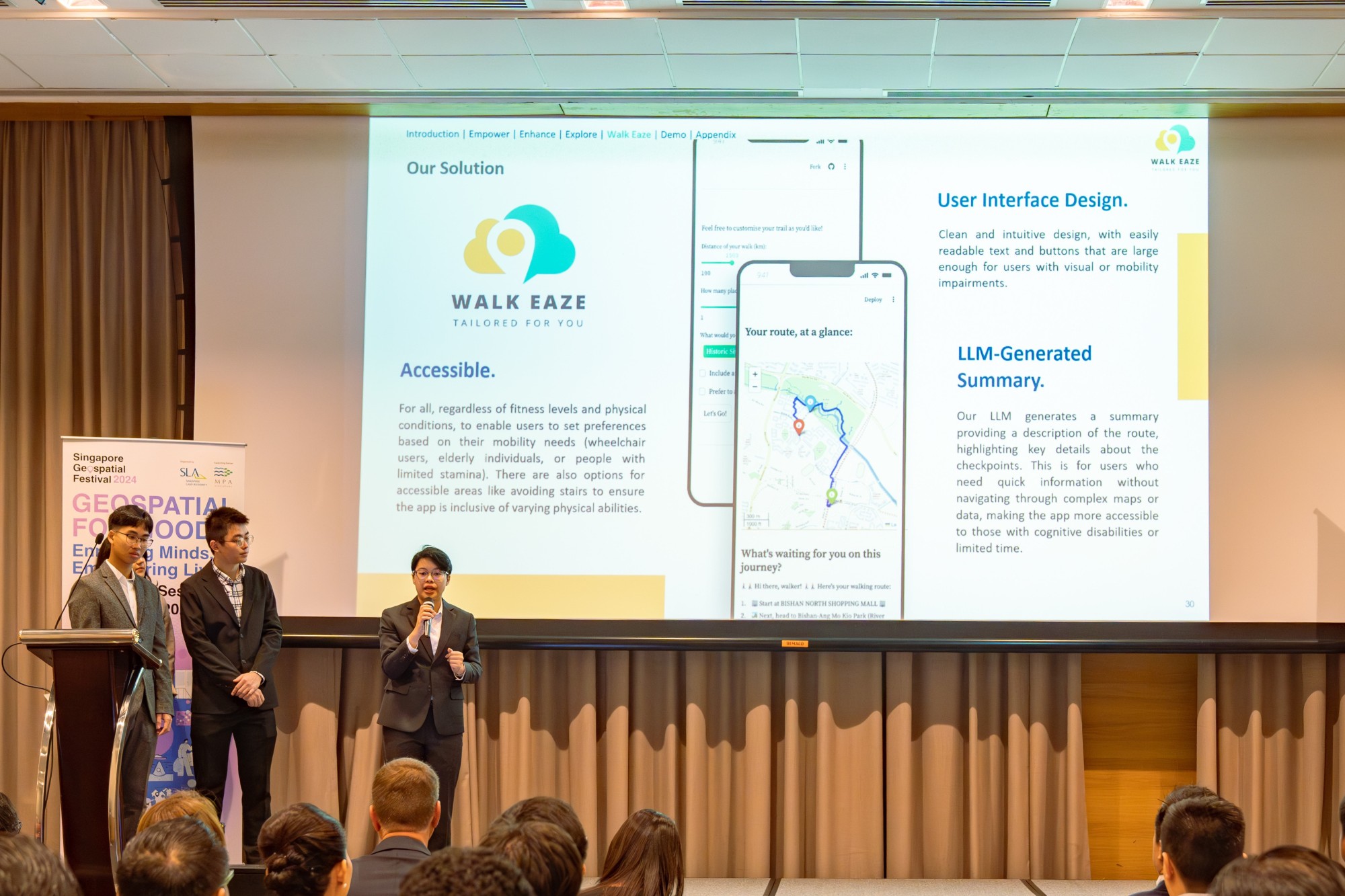
10 The winning team from SMU received their award from Mr Yeoh Oon Jin, Chairman, SLA, at the opening ceremony of GeoFest. SMU’s winning entry features an innovative prototype for an app, “Walk Eaze”, that transforms the walking and hiking experience for enthusiasts of all levels. Powered by OneMap’s walking route API, the app prototype can generate multiple unique paths for any given location, thereby offering walking experiences that can be customized by users based on distance, terrain, inclines, and landmarks.
Please refer to Annex D for the photograph of the presentation by SMU.
GeoFest Highlights
11 GeoFest 2024 features three full days of workshops, presentations and activities that highlight the transformative role of geospatial technologies and applications. In line with its theme, there will also be an exhibition that showcases geospatial-related student projects from Singapore Management University (SMU), National University of Singapore (NUS), Singapore Institute of Management (SIM) and Temasek Polytechnic (TP).
12 The line-up of the activities organised during Singapore Geospatial Festival 2024 is available at the event website at: Singapore Geospatial Festival 2024 (sla.gov.sg)
=== End ===
ANNEX A
Opening Address by Mr Yeoh Oon Jin, Chairman, Singapore Land Authority
at the Opening of the Singapore Geospatial Festival 2024
Lifelong Learning Institute at Paya Lebar, Singapore
15 October 2024, Tuesday
Opening
Mr David Foo, Assistant Chief Executive, Maritime and Port Authority of Singapore
And Mr Scott Simmons, Chief Standards Officer, Open Geospatial Consortium
Distinguished guests,
Ladies and Gentlemen,
Good morning.
1. A very warm welcome to all of you to the opening of the Singapore Geospatial Festival 2024 (‘GeoFest’).
2. It is my pleasure to kick off this week of talks, workshops, and co-located activities dedicated to promoting the innovative use of geospatial information and technology.
3. This year’s theme is ‘Geospatial for Good: Enriching Minds, Empowering Lives’, and it is the sixth year that the Singapore Land Authority (‘SLA’) is organising GeoFest.
4. It is, however, the first time that SLA is organising GeoFest with the Maritime and Port Authority of Singapore (‘MPA’) as a supporting partner.
5. SLA and MPA launched the refreshed Singapore Geospatial Master Plan earlier this year in March at Geo Connect Asia. The new Master Plan has 3 key pillars or focus areas – Mainstreaming, Deepening Capabilities, and Going Global. The Master Plan embodies the combined commitment of Singapore’s land and sea agencies to accelerate geospatial usage and development over the next decade.
6. GeoFest is just one of the many events where we aim to gather geospatial expertise and share valuable insights, both from the land and marine perspectives.
7. I am happy to update that SLA and MPA are making good progress on the new Master Plan.
Mainstreaming
8. As part of the Mainstreaming pillar of the Master Plan, we are exploring ways to maximise the full potential of geospatial by embedding its usage in every facet of society.
9. A key focus is the usage of geospatial in the healthcare industry. SLA recently embarked on a living asset mapping project to enable social prescribing in collaboration with SingHealth Community Hospitals. With the team’s easy-to-use map, social prescription practitioners can quickly locate and recommend community activities to improve their patients’ health.
10. I am proud to share that the team’s efforts have been recognised in multiple forums, such as the GeoInnovation Award, which was awarded to the team by ESRI Singapore in April this year. In addition, SingHealth’s Social Prescribing Team received the National Clinical Excellence Team Award at the National Medical Excellence Awards just last month.
11. For those interested in learning about the project, the team will share more details during the Geospatial for Good segment later.
12. Geospatial for Good is all about using geospatial to benefit the society we live in. One way we are actively doing this is by mapping out Barrier-Free Access (‘BFA’) information across Singapore as part of the Barrier-Free Access project. Users can find and access such Barrier-Free routes on the OneMap app, making it easier to navigate different parts of the country. Today, we have completed mapping 1,100 km of accessible routes. We are working on extending coverage to more areas, such as the National University of Singapore (‘NUS’) campus which was recently completed with the help of NUS students and is available on the OneMap Android app as of today. As we improve and refine the Barrier-Free Access routing capabilities of OneMap, we hope that this will contribute towards a more accessible and inclusive Singapore for all.
13. Geospatial technology is a powerful enabler of not just the social and healthcare sectors, but also the real estate domain. SLA recently embarked on a collaboration with Inland Revenue Authority of Singapore (‘IRAS’) to explore the application of geospatial tools for property tax administration. The POCs developed with IRAS demonstrated the potential to streamline selection of similar properties, while assessing property values. It was also possible to harness geospatial analytics to glean insights on spatial attributes of different properties. Given the potential to develop further use cases, SLA and IRAS look forward to further advancing our geospatial journey.
14. In the current age, climate change remains a critical issue at the forefront of everyone’s minds. Naturally, geospatial is a core enabler of sustainable action as well. SLA, in partnership with MPA, PUB, Singapore’s National Water Agency, and the Centre for Climate Research Singapore, is working on establishing a long-term nation-wide infrastructure and operational system. This system will monitor and understand vertical land motion throughout the nation.
15. New insights will be generated through integration with existing systems such as SiReNT. By continually collecting accurate and high-resolution vertical land motion measurements, a holistic and reliable new dataset for Singapore will be created. The valuable information produced can be directly linked to sea level rise, and will support national efforts in climate change adaptation and risk mitigation, as well as data collection digitalisation.
16. Our youth also play a pivotal role in mainstreaming the usage of geospatial. SLA recently concluded the Amazon Web Services Geospatial Innovation Challenge. The competition challenged students to create unique solutions to address social and healthcare needs in Singapore, and we will hear more from the winning team in their presentation after this.
Deepening Capabilities
17. On this note, the Deepening Capabilities pillar focuses on strengthening our core competencies and improving the geospatial capabilities of our workforce. Last year at GeoFest, we launched the Graduate Certificate in Applied Geographic Information Systems (‘GIS’) in partnership with the National University of Singapore (‘NUS’). Today, I am happy to share that the Professional Certificate in Applied GIS will also be accepting its first intake this month.
18. The Graduate Certificate, launched by NUS in May 2023, and Professional Certificate go hand in hand to ensure a holistic geospatial education for working adults. While the Graduate Certificate caters to those wishing to deepen their GIS knowledge between six to 36 months, the Professional Certificate provides an introduction of foundational GIS concepts and skills over six days.
19. If you are interested in upgrading your skills or are looking to transition into a geospatial career, do take a look at the Applied GIS offerings on the NUS Department of Geography’s website after this session.
20. Finally, I am pleased to announce that SLA will be signing a MOU with the Open Geospatial Consortium (‘OGC’) today. Under the Going Global pillar of the Master Plan, we are constantly looking for opportunities to tap on the wealth of knowledge that the international community of geospatial experts has to offer.
21. We are honoured to continue partnering the OGC in standards development and capacity building. For example, the OGC and SLA will collaborate on outreach events and activities, such as the OGC Singapore Forum. We will also work closely to curate technical collaborations, workshops, and training sessions to enhance geospatial knowledge in Singapore.
Closing
22. To conclude, I strongly encourage each of you to embrace the spirit of innovation and engage actively in the events held throughout this week. The usage of ‘Geospatial for Good’ will lead us to a smarter, more inclusive future for our organisations and the citizens we serve.
23. Thank you, and I wish everyone a fulfilling week ahead.
ANNEX B
Memorandum of Understanding between Singapore Land Authority (SLA) and Open Geospatial Consortium (OGC)

Photo caption: Mr Sin Lye Chong, Assistant Chief Executive (Geospatial & Engagement) and Chief Sustainability Officer, Singapore Land Authority, (right) and Mr Scott Simmons, Chief Standards Officer, Open Geospatial Consortium (left), signed a new Memorandum of Understanding (MOU) on 15 October, to expand community and industry outreach and enhance geospatial capabilities. The MOU signing was witnessed by Mr Yeoh Oon Jin (centre), Chairman, Singapore Land Authority.
“As the national geospatial and mapping agency, SLA aims to drive geospatial outreach and capability-building, in line with the objectives of the Geospatial Master Plan 2024-2033. SLA is delighted to partner with Open Geospatial Consortium, to harness synergies and jointly develop a holistic approach to uplift geospatial advancement in Singapore through open standards and technologies, while deepening community and industry engagement.”
- Mr Sin Lye Chong, Assistant Chief Executive (Geospatial & Engagement) and Chief Sustainability Officer, SLA
ANNEX C
ULI Singapore – SLA Forum:
Unlock the Power of Geospatial for Sustainable Urban Development

ANNEX D
AWS – SLA Geospatial Innovation Challenge
Presentation by winning team from Singapore Management University

Photo caption: The winning team from Singapore Management University presenting their winning prototype Walk Eaze at the opening ceremony of GeoFest 2024
